U CARE COVID-19
Mobile app
2020


PRoject Description
COVID-19 is a problem that requires efforts at the community level to contain its spread. U Care COVID-19 mobile app will help students, faculty and staff access COVID-19 related information. At the core of this project we want to help protect each other and sustain a healthy campus environment.
PRoduct Description
An opportunity for a location-based app revolving around COVID-19 has introduced itself to the University of Miami community. The purpose of U Care COVID-19 app aims to allow the student body and faculty to easily locate resources such as personal protective equipment (PPE), testing location, and location densities to raise awareness of safe practice while also providing essential resources links to COVID-19 hotline and additional resources.
PRoject Details
-
Timeline:
-
August 24th- August 31: Empathize, Define, Research
-
August 31-October 11th: Ideate, Design
-
October 11th: Finish prototype
-
Total duration: 8 weeks
-
-
Goal
Help the UM community sustain a healthy environment
Role
UX Researcher
UI Designer
Team
6 teammates/ researchers
in total
Research
To better understand the experiences, needs and wants of students and faculty regarding to COVID-19, the team conducted semi-structured, 1:1 interviews with 18 participants using a discussion guide and a pre-survey questionnaire to gather qualitative data such as demographics, learning/teaching mode, age, mobile app familiarity, and experience with UM app.
Key Results
-
Based on interview responses are grouped in three main areas:
-
Location Density
-
Most participants were unaware of the location density feature.
-
-
Access to essential resources
-
Some voiced the lack of accessibility of PPE's and have expected more access to hand sanitizers on campus
-
-
Access to COVID-19 related information
-
Clarity and transparency in their communication, as a pattern of difficulty in accessing the information / available resources
-
-
Concept Map

Sketches

Affinity MApping
Design Strategies
-
Real-time location density feature
-
Wayfinding to the campus buildings and essential resources (PPE, testing site)
-
Peak time feature showing when a space is most busy / clustered
-
Color-blind accessible/high contrast tool in location densities table
Features, functions, task lists
-
Locate PPE stations
-
Get directions to PPE stations
-
View image of the selected PPE station
-
-
Locate testing site
-
Get directions to testing location
-
View image of the testing location
-
-
View location densities
-
Location density table at a glance
-
View peak times of locations
-
Status key to indicate whether a space is safe to enter or not
-
Color blindness accessibility tool/ high contrast
-
-
Book appointments
-
For COVID-19 testing
-
For booking a seat at the library
-
-
Access to COVID-19 related information
-
WHO
-
CDC
-
Florida COVID-19 Response
-
U.S Department of State Travel Advisories
-
-
Get technical support

Task Flows

Site map

Wireframes

-
Enter Cane ID and password to sign in
-
Choose mode of verification to duo authenticate the account
Log in
Duo authenication
-
Use search bar to find location of interest
-
Interactive campus map
-
Tap on the hamburger menu to expand navigation options
-
Tap to show PPE stations or testing location on the map

Landing page
Navigation
Map Navigation
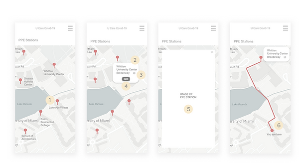
PPE Stations
Get directions
View image
Route

-
Tappable red pins indicate PPE station locations
-
White box to provide location information
-
Tappable image icon that shows the actual image of the selected PPE station
-
GO button to get directions
-
Real-life image of the PPE station
-
Route from current location to selected PPE station
Style Guide


Prototype
